
Photo Location Finder vs. Reverse Image Search: Your Guide to Finding Image Locations
Have you ever stumbled upon a breathtaking photo and wondered exactly where on Earth it was taken? In the digital age, solving this mystery often leads to two distinct paths: using a dedicated photo location finder or a general reverse image search. But which tool is right for the job? How to find the location of a photo with precision depends entirely on understanding the fundamental differences between these technologies.
As a professional online tool reviewer, I’ve tested countless platforms designed to analyze images. This guide will cut through the confusion, comparing a specialized tool like an AI-powered analysis with the more familiar reverse image search. We'll explore how they work, their key differences, and the best scenarios for each, so you can choose the right tool to uncover the story behind your pictures.
What is a Photo Location Finder?
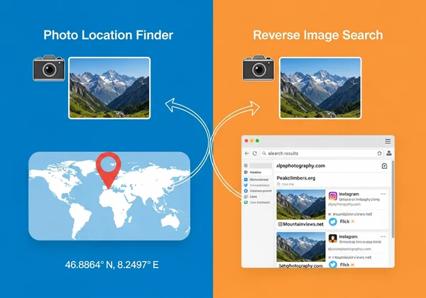
A photo location finder is a highly specialized tool designed for one primary purpose: to determine the precise geographic location where a photo was captured. Unlike general search engines, these platforms use a combination of data extraction and sophisticated analysis to pinpoint coordinates on a map. They are built for accuracy and detail, serving everyone from professional photographers and journalists to curious travelers.
How Dedicated Geolocation Tools Work
The process is typically straightforward and user-centric. You start by uploading your image to the platform. The tool then initiates a deep analysis, scanning the image file for hidden clues. Within moments, it presents the most probable location on an interactive map, often complete with latitude and longitude coordinates. The goal isn't just to find a similar image but to geolocate the original scene with as much accuracy as possible.
The Role of EXIF Data and AI Visual Analysis
These tools derive their power from a hybrid approach. First, they scan for EXIF data (Exchangeable Image File Format), which is metadata embedded in many digital photos. This data can include GPS coordinates, the camera model, and the date and time the photo was taken. If GPS data is present, the location can be identified almost instantly.
However, the real magic happens when EXIF data is missing. This is where AI visual analysis comes in. An advanced AI model scans the image for visual clues—identifiable landmarks, unique architectural styles, specific types of vegetation, terrain, and even the angle of the sun. It cross-references these elements against a massive database of geographical information to deduce the location. This dual-engine approach makes modern image location finders incredibly powerful.

Understanding Reverse Image Search
A reverse image search location tool operates on a completely different principle. Instead of analyzing the content of a photo to find its real-world location, a reverse image search engine scans the internet to find where that exact image (or visually similar ones) appears online. Services like Google Images or TinEye are prime examples. Their primary function is to trace an image's digital footprint across the web.
How General Reverse Image Search Works
When you upload an image to a reverse image search engine, it creates a digital fingerprint of that image based on its colors, shapes, and patterns. It then scours its index of billions of web pages to find matching or similar fingerprints. The results will show you a list of websites, articles, and social media posts where that image has been published.

What Can Reverse Image Search Tell You? (And What It Can't)
Reverse image search is excellent for finding the image source. It can help you identify the original creator of a photograph, find a higher-resolution version, or debunk a fake news story by seeing where an image was previously used.
However, it is not designed to find a geographic location. While you might get lucky if an image is published in an article that names the location (e.g., "A photo of the Eiffel Tower in Paris"), the tool itself does not provide coordinates. If the image is a personal photo from your camera roll that has never been online, a reverse image search will likely find nothing at all.
Key Differences: Find Location vs Reverse Search
Choosing the right tool boils down to understanding your goal. Are you looking for a place on a map or a place on the internet? The answer determines which technology will serve you best. A direct find location vs reverse search comparison reveals critical distinctions.
Accuracy and Specificity in Geolocation
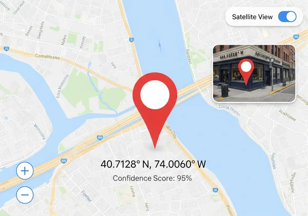
A photo location finder is built for precision. Its entire purpose is to provide specific geographic coordinates. The result is a pin on a map, often accurate down to a few meters. In contrast, a reverse image search offers no guaranteed geographic accuracy. Any location information you find is secondary and dependent on the context provided by the websites where the image is found.
Identifying Image Source vs. Geographic Coordinates
This is the most crucial difference. A reverse image search answers, "Where has this image appeared online?" A photo location finder answers, "Where was this photo physically taken?" One traces the digital history of an image file, while the other reconstructs its real-world origin. For anyone needing to verify a location for journalistic, investigative, or travel purposes, a dedicated photo location finder is the only reliable option.
Data Sources: Metadata vs. Visual Matching
The underlying technologies are fundamentally different. A location finder dives deep into the file's metadata and analyzes the actual content (landmarks, flora) with AI. A reverse image search performs surface-level visual matching to find digital copies. It doesn't understand what is in the photo; it only knows how to find visually similar images online.
When to Use Each Tool: Best Scenarios
Knowing the strengths and weaknesses of each tool allows you to build an efficient image analysis workflow.
Optimal Use Cases for Photo Location Finders
You should use a dedicated photo location finder when your primary goal is to discover the physical place shown in an image. Ideal scenarios include:
- Travelers: Identifying a beautiful landscape from an old travel photo or finding the name of a restaurant from a picture you took.
- Journalists and Investigators: Verifying the location of a user-submitted photo for a news story or authenticating evidence.
- Content Creators: Geotagging a large batch of photos to create an interactive travel map for a blog.
- Everyday Users: Remembering where you parked your car or finding the name of that park you visited last summer.
For these tasks, the precision of a tool that can discover the location is essential.
When Reverse Image Search is Your Go-To
Reverse image search excels when your goal is related to the image's online presence. Use it for:
- Fact-Checking: Finding the original context of a viral meme or image to see if it's being used misleadingly.
- Finding Products: Uploading a picture of an item to find out where you can buy it.
- Copyright Checks: Discovering if your original photography is being used on other websites without permission.
- Identifying People or Things: Finding the name of a celebrity or a specific landmark if it's famous and widely photographed.
Combining Both for Comprehensive Image Analysis
For advanced investigations, using both tools can be incredibly effective. You could start with a reverse image search to see if an image has been used in a news report that might give you some context. Then, use a photo location finder to independently verify the exact geographic location and confirm or deny the information from the report.
Why Photo Location Finder Excels: AI-Powered Precision
While both tools have their place, a modern, dedicated picture location finder offers a level of insight that reverse image search simply cannot match. Its specialized technology provides a more complete and trustworthy answer to the question, "Where is this?"
Beyond EXIF: How AI Enhances Location Discovery
The most significant advantage is the AI-powered analysis. Even if a photo has been stripped of its EXIF data—a common practice on social media platforms—the AI can still find the location. By recognizing architectural styles, plant life, and subtle landmarks, the AI can geolocate photos that would leave other methods at a dead end. This makes it an indispensable tool for analyzing images from any source.
Transparent Results with Confidence Scores and AI Insights
Trust is paramount when verifying a location. The best geolocation tools don't just give you an answer; they show you how they got it. By providing confidence scores and outlining the AI's reasoning process (e.g., "Identified Eiffel Tower," "Detected Parisian architecture"), they offer a layer of transparency that builds credibility. This is something a reverse image search never provides.
Seamless User Experience and Interactive Map Display
Finally, dedicated platforms are designed with the user's goal in mind. They offer a clean interface for uploading images and present results on a dynamic, interactive map. You can zoom in, switch to satellite view, and get precise coordinates in multiple formats. This user-centric design makes the process of discovering a photo's origin both simple and engaging.
FAQ Section
Can AI truly find a location from any photo?
While AI is incredibly powerful, its success depends on the visual information available. An AI can find a location with high accuracy if the photo contains recognizable landmarks, unique buildings, or distinct geographical features. However, a close-up shot of a generic wall or a photo of a common object with no background will be very difficult, if not impossible, to geolocate. The best tools will provide a confidence score to reflect this.
How accurate are photo location finders compared to reverse image search?
When it comes to geographic accuracy, there is no comparison. A photo location finder can provide precise GPS coordinates. A reverse image search provides zero geographic data on its own; it only points you to websites where an image appears, which may or may not contain accurate location information. For reliable geolocation, a dedicated finder is vastly superior.
What if my photo has no EXIF data?
This is where a top-tier image location finder shines. While tools that only read EXIF data will fail, a platform with a powerful AI visual analysis engine can still succeed. The AI scans the image for visual clues to determine the location, making it possible to find photo location even from screenshots or images downloaded from social media.
Is it possible to find the exact street address from a photo?
A photo location finder can typically pinpoint a location on a map with high precision. This will give you the latitude and longitude, which you can then use in a mapping service like Google Maps to find the nearest street address. While the tool itself provides the coordinates, translating that to an exact street address is a simple final step.