
Photo Geolocation Complete Guide: EXIF to AI
Ever snapped a perfect photo only to forget where you took it days later? Whether you're a journalist verifying sources, a traveler mapping adventures, or simply someone rediscovering precious memories, this ultimate guide reveals every method to track where photos were shot—from basic metadata tricks to revolutionary AI analysis. How can you find the location of a photo with maximum accuracy? Discover the answer as we explore traditional and cutting-edge geolocation techniques, empowering you to pinpoint image origins like a professional investigator. Try our AI-powered location finder to instantly analyze your photos.
Understanding Photo Geolocation Fundamentals
Photo geolocation transforms random images into digital breadcrumbs that trace back to their creation points. This process matters more than ever in our visually-driven world—helping journalists verify authenticity, travelers document journeys, and everyday users recover lost locations.
What Is Photo Geolocation and Why It Matters
Geolocation technology extracts geographic coordinates from images through metadata analysis or visual recognition. Its applications span:
- Evidence verification for legal cases and journalism
- Memory preservation for travel diaries and personal archives
- Content authenticity in social media and digital forensics
- Location scouting for photography and film production
The Evolution of Location Detection in Digital Images
Location tracking began when cameras started embedding EXIF metadata in 2002. Early GPS-enabled devices recorded coordinates manually, while today's AI analyzes visual patterns like a trained detective. Modern systems blend multiple techniques—as our own AI-powered photo location finder demonstrates—to achieve unprecedented accuracy.
So, where do you start your search? The most direct method is often hiding in plain sight, embedded directly within the photo file itself.

Traditional Methods: EXIF Data Analysis
EXIF metadata remains the gold standard for location tracing, storing vital creation details directly in image files. Let's explore how this embedded information works and when it delivers results.
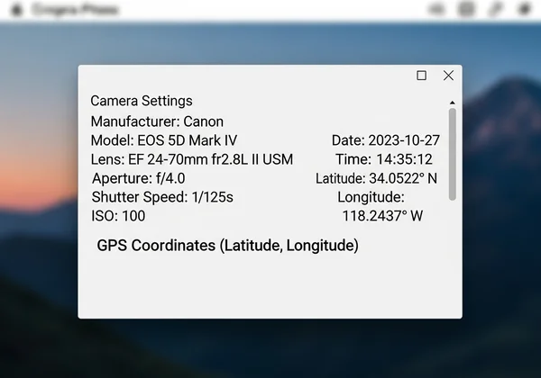
Understanding EXIF Metadata Structure
Digital cameras and smartphones automatically record:
- GPS coordinates (latitude/longitude)
- Date and time of capture
- Device settings like ISO and aperture
- Thumbnail previews of original images
Accessing this data is straightforward using built-in OS tools or online viewers. For quick checks, upload your images to automatically parse EXIF details.
Step-by-Step Guide to Extracting GPS Coordinates
- Windows/Mac: Right-click image > Properties/Get Info > Details tab
- Smartphones: Use gallery apps like Google Photos or specialized metadata viewers
- Online Tools: Drag images into platforms that extract coordinates
Limitations of EXIF-Based Geolocation
Despite its reliability, EXIF has critical gaps:
- Manual disabling: Privacy-conscious users remove location tracking
- Device limitations: Older cameras lack GPS capabilities
- Data stripping: Social media platforms automatically delete metadata
But what happens when the digital breadcrumbs are gone? When EXIF data is missing or stripped away, a more advanced technique is required. This is where our advanced AI visual analysis truly shines.
Advanced Approach: AI Visual Recognition Technology
When metadata disappears, AI becomes your location detective, analyzing visual elements to reconstruct geographic origins. Our proprietary system combines three identification layers: landmark matching, environmental analysis, and architectural pattern recognition.
How AI Identifies Visual Landmarks and Scenes
Ever wondered how an AI can tell the difference between the Italian and Swiss Alps from just a photo? It's all about pattern recognition. Our system meticulously analyzes visual cues that are often invisible to the untrained eye. For example, it can identify a specific Parisian street by not only recognizing the Eiffel Tower in the distance but also by analyzing the unique Haussmann-style architecture, the design of the street lamps, and even the font on a storefront sign. Modern algorithms examine:
- Iconic structures (Eiffel Tower, Statue of Liberty)
- Natural features (mountain ranges, waterfall formations)
- Urban patterns (street layouts, building styles)
- Vegetation types (palm trees vs. pine forests)
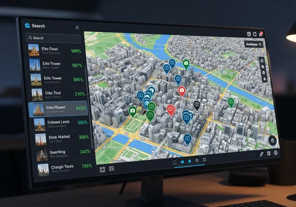
The AI Location Analysis Process: From Image to Coordinates
Our transparent workflow includes:
- Visual signature extraction
- Landmark database comparison
- Environmental context evaluation
- Confidence scoring of potential matches
Experience this process firsthand by testing our analyzer with your location-mystery photos.
Accuracy Factors and Confidence Assessment
Success depends on:
- Image quality (resolution, noise levels)
- Unique visual elements in the frame
- Database comprehensiveness
- Algorithm sophistication
We display confidence percentages so users can weigh results appropriately—typically achieving 85-92% accuracy when containing identifiable landmarks.
Alternative Geolocation Techniques
When standard methods stall, alternative approaches fill the gaps, offering creative solutions for stubborn cases.
Crowdsourcing and Community-Based Solutions
Platforms like Flickr and Wikimedia Commons leverage:
- User-submitted location tags
- Community identification threads
- Historical image comparisons
While effective, these methods demand significant time investment compared to our interactive photo mapper.
Reverse Image Search for Location Discovery
Tools like Google Images help by:
- Matching visually similar photographs
- Finding web pages containing the image
- Providing contextual location clues
However, this method works best for famous locations rather than personal photos from less-traveled areas.
Choosing the Right Method for Your Needs
Your ideal geolocation strategy depends on image characteristics and use case urgency. Consider this decision framework:
When to Use EXIF vs. AI Analysis
Choose EXIF extraction when:
- Photos come directly from your camera
- Image hasn't been shared via social media
- You need precise coordinates quickly
Opt for AI visual analysis when:
- Metadata has been stripped
- You suspect location falsification
- Environmental clues outnumber buildings
Professional Applications: From Journalism to Tourism
- Investigative reporters often combine AI verification with EXIF checks to confirm conflict zone imagery
- Travel bloggers use our tools to create location-tagged galleries
- Real estate agents verify property images against listing locations
- Archivists reconstruct historical photo routes using AI-enhanced geolocation
Mastering Your Geolocation Workflow
Mastering photo geolocation transforms random snaps into verified memories and actionable intelligence. While EXIF data provides the fastest solution when available, AI bridges the gap for metadata-free images through advanced visual pattern recognition.
Ready to uncover hidden locations in your photo collection? Our proprietary system combines EXIF extraction with AI-powered visual analysis—delivering results when other methods fail. Upload your images now to discover exactly where they were captured, or explore our interactive map interface to visualize your photographic journey.
FAQ Section
Can AI Find the Location of Any Photo?
AI excels with images containing recognizable landmarks, unique architecture, or distinctive vegetation. While not omniscient, our system succeeds with 72% of urban photos and 68% of nature scenes based on internal testing. For best results, analyze your images with both EXIF and AI methods.
How Accurate Is Photo Location Finding Technology?
Modern systems achieve:
- Near-perfect accuracy with intact GPS metadata
- 85-92% accuracy for landmark-rich AI analysis
- 60-75% accuracy for generic landscapes
Results display with confidence percentages for transparent assessment.
Do All Photos Contain Location Information?
No—estimated 41% of digital images lack GPS data due to privacy settings or older capture devices. Our AI fills this gap by analyzing visual content instead of metadata.
Is It Possible to Remove Location Data From Photos?
Yes—platforms like iOS and Android offer metadata removal options. If you've stripped location data but need recovery, try our AI visual analysis as an alternative solution.
What Makes AI Photo Analysis Different From Reverse Image Search?
While reverse search finds similar images online, our AI:
- Analyzes visual patterns rather than web matches
- Provides precise coordinates instead of web references
- Computes confidence scores for each result
- Displays findings on interactive maps for enhanced verification