
AI Photo Location Finder: A Case Study of Challenging Images
Ever been stumped by a photo with no obvious clues? We’ve all seen them: images with no landmarks, missing EXIF data, and generic landscapes that could be anywhere in the world. These scenarios defy traditional search methods, leaving us to wonder. Can AI find a location from a photo that seems impossible to place? This case study demonstrates how an advanced photo location finder rises to the occasion, unraveling the hidden geography of even the most cryptic images through a transparent and powerful analytical process. Put your own mysteries to the test and analyze your image.
The Challenge: Decoding Photos with Minimal Clues
Finding a photo's origin is straightforward when you have a clear shot of the Eiffel Tower or embedded GPS data. But what happens when those easy identifiers are missing? The real test for any geolocation tool lies in its ability to work with incomplete information. This is where many platforms falter, but where a sophisticated AI can truly demonstrate its power.
Why Traditional Geolocation Methods Fall Short
Most basic image location tools rely heavily on two things: EXIF metadata and reverse image searching. EXIF data, which contains GPS coordinates, is often stripped by social media platforms to protect privacy. Reverse image searching is only effective if the exact or a very similar image already exists online with a known location. When faced with a unique, personal photo of a non-descript street or a wild landscape, these methods are often useless. They lack the cognitive ability to analyze the actual content of the image for subtle geographical hints.
Defining a 'Challenging Photo' for AI Analysis
For the purpose of this analysis, a 'challenging photo' is one that exhibits several of the following characteristics:
- No EXIF Data: The image file contains no embedded GPS coordinates.
- Absence of Major Landmarks: There are no world-famous monuments, buildings, or natural wonders.
- Generic Scenery: The photo depicts a common scene, such as a suburban street, a patch of forest, or a generic coastline.
- Obscure Details: Clues like text on signs are blurry, distant, or in a common language like English.
- Low Resolution: The image quality is poor, making it difficult to discern fine details.
These are the images that require more than a simple database lookup; they require genuine digital deduction.
Photo Location Finder's AI: Our Advanced Image Analysis Approach
To tackle these challenges, our platform employs a hybrid engine that goes far beyond basic metadata checks. It uses a sophisticated AI model trained on millions of geotagged images to perform a deep visual analysis, effectively mimicking the deductive process of a seasoned geographical investigator. It’s this advanced method that allows users to find your photo location with surprising accuracy.
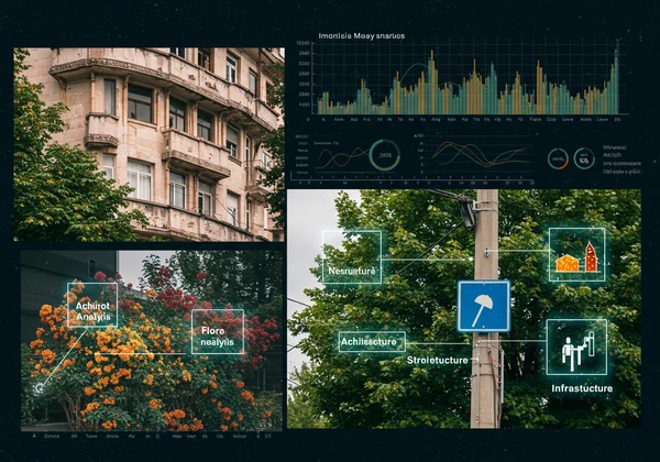
Leveraging Visual Cues: From Flora to Architecture
Our AI doesn't just see pixels; it identifies objects and patterns, then cross-references them with vast geographical datasets. It looks for unique visual fingerprints that can pinpoint a region, city, or even a specific street corner. These cues include:
-
Architecture: Are the roof tiles terracotta, slate, or something else? Are the window styles characteristic of a particular country or historical period?
-
Flora and Fauna: The species of trees, flowers, or even birds can narrow down the location to specific climates and continents.
-
Infrastructure: The design of streetlights, fire hydrants, manhole covers, and road markings vary significantly from one country to another.
-
Topography: The AI analyzes soil color, rock formations, and the shape of hills to match the landscape to known geographical areas.
The Power of AI-Driven Pattern Recognition for Geolocation
The true strength of the AI is its ability to synthesize these individual clues into a coherent conclusion. It might identify three seemingly unrelated elements in a photo, but its pattern recognition capabilities allow it to find the one place on Earth where all three of those elements coexist. This process calculates probabilities and generates a confidence score, providing a transparent assessment of the proposed location's certainty. It’s not just finding a location; it’s showing its work.
The Case Study: Unveiling the Location, Step-by-Step
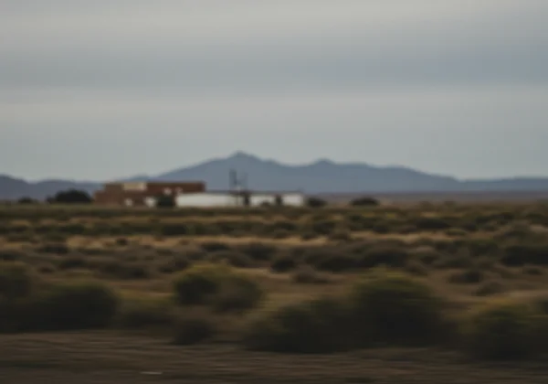
Let's consider a genuinely challenging image: a photo taken from a moving car, showing a roadside with some vegetation, a fence, and a distant, non-descript building. The image is slightly blurry, has no EXIF data, and lacks any text or license plates.
Initial AI Scan: Gathering Every Latent Detail
Upon uploading the image to the Photo Location Finder, the AI begins its initial scan. The transparent inference process immediately shows its first steps. It disregards the blurry foreground and focuses on stable elements:
- Vegetation Analysis: It identifies the trees as Eucalyptus and the low-lying shrubs as a type of saltbush common to arid or semi-arid climates.
- Infrastructure Scan: It analyzes the fencing style, noting it as a type of wire fence frequently used in rural agricultural areas.
- Soil and Light Analysis: The soil has a distinct reddish hue, and the quality of the sunlight suggests a location in the Southern Hemisphere.
Deductive Reasoning: How AI Connects the Dots Visually
Here, the AI moves from identification to synthesis. It knows Eucalyptus trees are native to Australia. The presence of saltbush and red soil strongly supports this, pointing toward the Australian Outback. The fencing style is consistent with Australian sheep or cattle stations. The AI cross-references these visual markers, and its algorithm begins to converge on a specific region. It discards other locations with Eucalyptus (like California) because the combination of soil type and specific undergrowth doesn't match.
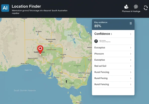
From Clues to Coordinates: Presenting the Location with Confidence
After processing thousands of data points, the AI presents its findings. It identifies a likely location along a stretch of the Barrier Highway in South Australia, known for its red soil and specific vegetation. The map on the screen pinpoints a coordinate, and the results card displays a confidence score of 85%. It also lists the key visual evidence it used—"Eucalyptus," "Red Soil," and "Rural Fencing"—giving the user full transparency into its conclusion. This is the power of advanced AI analysis in action.
Beyond Doubt: Trusting AI for Even the Toughest Geolocation
A challenging photo with minimal clues is no longer an unsolvable puzzle. As this case study demonstrates, advanced AI can dissect an image, identify subtle geographical fingerprints, and deduce a location with remarkable accuracy. By making its reasoning process transparent, the Photo Location Finder builds trust and transforms a black box of technology into a clear, understandable tool.
The next time you find a photo that leaves you guessing, don't give up. The answer might be hidden in the leaves of a tree or the style of a fence post, just waiting for the right technology to find it. Ready to solve your own photo mysteries? Upload your photo today and see what our AI can uncover for you.
Frequently Asked Questions About AI Photo Geolocation
How does Photo Location Finder handle images without EXIF data?
When EXIF GPS data is absent, our tool relies entirely on its advanced AI visual analysis. The AI scans the image for dozens of geographical clues, such as architecture, plant life, soil color, and infrastructure styles, to determine the location without needing any metadata.
Can AI accurately find locations from blurry or low-resolution photos?
Accuracy depends on the visibility of key details. While severe blur can obscure crucial information, our AI is trained to extract clues from imperfect images. It will attempt to identify any discernible patterns or objects and provide a location suggestion with a corresponding confidence score, letting you know how certain it is. You can try our AI tool to see how it performs on your images.
What specific visual clues does the AI use to identify a location?
The AI uses a vast range of clues, including but not limited to: architectural styles (roofs, windows), types of vegetation, road markings, designs of utility poles and street signs, topography (mountains, coastlines), soil and rock formations, and even the type of light and shadows, which can suggest a hemisphere.
How confident is the AI in its location suggestions for challenging images?
Our system provides a "confidence score" with every result. For a clear image with distinct landmarks, this score may be very high (e.g., 95-99%). For more challenging, ambiguous images, the score will be lower, reflecting the AI's assessment of the evidence. This transparency ensures you understand the reliability of each result.